Flame Chub Presence/Absence Maps
I wanted to post one of the county maps from my flame chub survey of the past 16 months. The maps were created in ArcInfo by Kevin Hammons, a student working with me. They're designed to show sites where flame chubs are known to have been collected since 1966 as represented by collections in the University of Alabama Ichthyology Collection (thanks again Bernie!). Three possibilities exist for these locations: either we found flame chubs there (in green on the map), we visited the location but didn't find flame chubs there (in red on the map), or we didn't visit the site (in black on the map). I'm sure the image below is too small to read well, to enlarge it click on it. Lauderdale County is the northwestern corner of Alabama, with Mississippi to the west and Tennessee to the north.
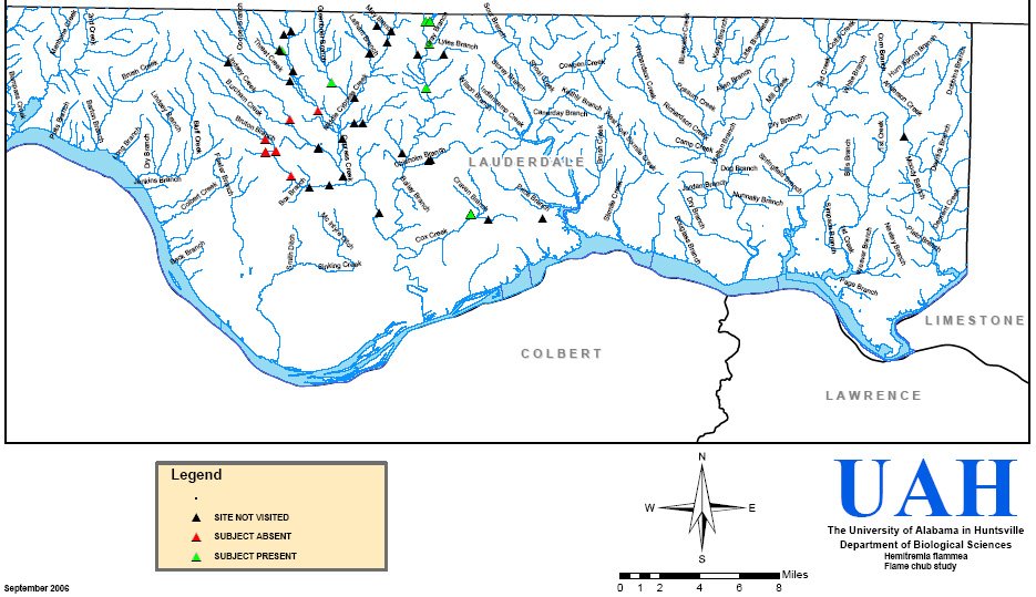
Lauderdale County is the best of the counties we visited (8 in total) for number of flame chub sites, and percentage of "present" sites. The Cypress Creek system that we visited on three locations is large, rising in Tennessee, and for the most part still in good shape. The big exception to that is the Burcham Creek system, the western arm of this system. These were sites that are now dry, and were bone dry for hundreds of meters up and down stream. Several of those sites showed evidence of being dug up as part of what can only be described as "trailer suburbia".
The Lauderdale County sites also showed evidence of healthier populations of flame chubs, since we could always catch more than one flame chub without a major effort. This is very different from many other sites in other counties we visited and found only a single flame chub in as much as two hours of seining. So the Cypress Creek system appears to be the sweet spot for flame chubs in north Alabama.
posted by Bruce Stallsmith @ 5:48 PM
0 comments
![]()

0 Comments:
Post a Comment
<< Home