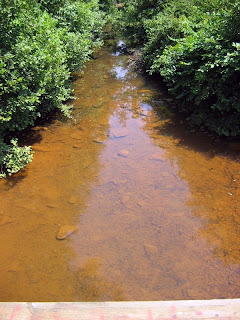
Photos Of Cohobadiah Creek On August 8
Here are two photos of the one good stream we found on our last trip to the Little Tallapoosa River system on August 8. On the map it's labelled as Cohobadiah Creek (pronounced "Coh-WHO-ba-die-ah" by locals) although one truckload of passersby claimed that it's really Cool Springs Creek, and indeed there is a Cool Springs Church about a mile down the road. It's just inside of Randolph County on a dirt County Road. The county line between Randolph and Cleburne counties is marked by a poorly paved road in Cleburne County becoming a dirt road in Randolph. The surrounding land is apparently owned by a mining company who used to mine coal in the area, and there are poorly gated mine shafts in the area. Even weirder, there may be some gold in the area, which of course attracts people into the abandoned mine shafts with predictable results.
So, the water in this creek was clear although there was a layer of sediment on the bottom which is why it looks reddish-brown in the first photo. We caught a fair number of fish, especially tallapoosa and bandfin (maybe striped?) shiners and more than the usual number of stonerollers and creek chubs. But, no stippled studfish were found. Even though this creek is in better shape than others locally, it still has no good habitat for stippleds: long stretches of sand, especially in areas of sunlight. Instead the creek bottom was mostly bedrock and cobble, with some gravel. So it's another case of no good habitat meaning no stippleds are found locally, one of the big themes of the summer.
 The photo below shows a pool constructed by some local people just below the bridge. It's surprisingly well built. The intention of this dam is to create a swimming hole, especially for a legless man who can be driven to the edge of the pool and slide into the swimming hole. I admit that's a first for me. The guy who told me all of this was driving an ancient pickup, with a heavy theme of flaming skull decorations in the cab and his tattoos. I also asked him if there was any timber activity locally, and he said no, explaining about the coal mines and shafts.
 This sad result along the Cleburne/Randolph county line furthers my interpretation that stippled studfish are now found no further north than Cornhouse Creek in Randolph County. Cohobadiah Creek flows off of Turkey Heaven Mountain to the north. Such creeks are usually cleaner and have a higher gradient than what we found in the area, so if Turkey Heaven's creeks were ever habitat for stippleds that's long gone as these creeks have been degraded. What surprises me is that a relatively sparse human population has had this profound an effect on the area.

0 Comments:
Post a Comment
<< Home