Satellite Image Of Chlorophyll-a In Lake Harris
I'd like to thank Prof. Han at the University of Alabama in Tuscaloosa for preparing this image.
News, Views, And General Gossip About Native Fishes Research In Alabama
The Association of Southeastern Biologists (ASB) will meet in Huntsville in March or April of 2011. I will be working as local host on behalf of our Department of Biological Sciences at the University of Alabama in Huntsville. This meeting draws upwards of 1200 participants, so it's a good-sized meeting. It will take place at the von Braun Center (VBC) in town (yeah, shooting Nazi rockets and all of that stuff...) which will be a good venue.
We've largely finished our sampling of the Tallapoosa basin for stippled studfish, and I think we've demonstrated that the species' range is relatively limited. I've found two sources of information about the physical condition of this basin. The first is Professor Han from the University of Alabama in Tuscaloosa, who's a geographer working with remoting sensing data. He has a set of images that show the Tallapoosa River and Little Tallapoosa River to be largely eutrophic (nutrient enriched), with the exceptions of the impoundments Lake Wedowee (a.k.a. Harris Reservoir) and Lake Martin which are strangely low nutrient. Some of the Tallapoosa tributaries where we collected stippled studfish such as Hillabee Creek show up as low nutrient too, which would be my guess from having seen the clear water of the creek. And this low nutrient environment is crucial to stippled studfish, since they don't do well with creeks with algae growing both on the bottom and in the water column.
For a view or download of my article in S.E. Naturalist last December, visit this link:
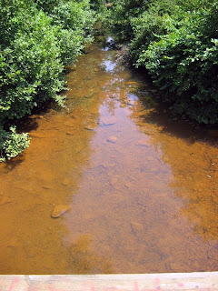
Here are two photos of the one good stream we found on our last trip to the Little Tallapoosa River system on August 8. On the map it's labelled as Cohobadiah Creek (pronounced "Coh-WHO-ba-die-ah" by locals) although one truckload of passersby claimed that it's really Cool Springs Creek, and indeed there is a Cool Springs Church about a mile down the road. It's just inside of Randolph County on a dirt County Road. The county line between Randolph and Cleburne counties is marked by a poorly paved road in Cleburne County becoming a dirt road in Randolph. The surrounding land is apparently owned by a mining company who used to mine coal in the area, and there are poorly gated mine shafts in the area. Even weirder, there may be some gold in the area, which of course attracts people into the abandoned mine shafts with predictable results.
I stayed at the Dauphin Island Sea Lab at the mouth of Mobile Bay this past weekend, largely doing my job as liaison between UAH and DISL. I met the new director, Dr. Scott Quackenbush, and talked about DISL's summer school offerings and how they might better serve more students. A big question is scheduling classes so that they don't interfere with the member schools, both at the beginning and the end of the summer. I don't have any snappy ideas on the subject, but then we haven't had any conflicts with UAH classes so it's not an immediate problem for me. All of our students did well this summer as usual; they go to DISL to study and have fun, not to drink beer 24 hours a day (round up the usual suspects).
We made it down to the Little Tallapoosa River drainage yesterday, along the Cleburne and Randolph County border. The river enters Alabama from Georgia here, and it's a mess. Below is a photo of the Little Tallapoosa at Cleburne County Road 49 near Ranburne, AL. If, as is likely, this river supported stippled studfish populations, it doesn't now. It's loaded with sediment and the substrate is soft unconsolidated sediment. Several creeks we looked at were smaller versions of this, the result of agricultural land uses and attendant nutrient enrichment running off into streams. All of the structures I saw in Google Earth images that I thought were poultry houses, really were, and there are lots of them in this area and upstream in Georgia. So there are a lot of relatively small contributors to these degraded streams, which is a sad story; you can't blame any one polluter because it's really almost everyone.
On the advice of Leland in another lab, we're switching to GeneClean kits for purifying DNA from gels of PCR products. Leland's experience is that the Qiagen kit we've been using tends to trap too much DNA during purification, leading to low DNA concentrations in your product (kinda like we've found). So, for another $146 and change, I'm ordering a kit good for 200 preps. Hopefully we'll have it by the end of the week and it'll make a difference as we PCR our current purified PCR product. We don't even have 40 samples in our screening of stippled studfish DNA, so that kit should do us. The piss of it is that I still have a fair number of the Qiagen spin columns used in their process. And I'm still within budget for the project; since I'm not getting Defense or NASA money I pretty much have to stay within budget, of course...